Jiri to Gokyo Lake via Cho La Pass trek
Trip Overview
The Jiri to Gokyo Lake via Cho-La Pass trek is also a mesmerizing odyssey that encapsulates the breathtaking beauty and rugged allure of the Himalayas. Beginning in the quaint town of Jiri, the trail winds through picturesque villages, terraced fields, and lush forests, offering trekkers an intimate glimpse into the traditional Sherpa way of life. As the path gradually ascends, the landscape transforms, revealing panoramic vistas of towering peaks and serene valleys. The highlight of this trek is undoubtedly the stunning Gokyo Lakes, a series of turquoise alpine jewels nestled amidst the mountains. The ascent to Gokyo Ri also rewards adventurers with awe-inspiring views of Everest, Lhotse, Makalu, and Cho Oyu. However, the journey's pinnacle challenge lies in crossing the Cho-La Pass, a demanding yet exhilarating high-altitude experience. The pass, adorned with glaciers and surrounded by snow-clad giants, connects Gokyo Valley to the Everest Base Camp route, offering a thrilling sense of accomplishment. En route, trekkers encounter cultural treasures such as Namche Bazaar and the Tengboche Monastery, enriching the journey with insights into Sherpa traditions. The trail's accommodations range from charming teahouses to tented camps, providing a blend of rustic comfort and genuine hospitality. The Jiri to Gokyo Lake via Cho-La Pass trek is not merely a physical feat; it's a spiritual and emotional voyage. It demands resilience, adaptability, and a profound connection to the natural world. The diverse landscapes, challenging terrain, and cultural encounters make this trek a transformative adventure, fostering personal growth and self-discovery. As trekkers stand atop Gokyo Ri, traverse the formidable Cho-La Pass, and immerse themselves in the serenity of the lakes, they forge memories and connections that will endure long after the journey's end. This expedition captures the essence of the Himalayan spirit – untamed, majestic, and life-changing.Trip Highlights
- Refreshing Journey to Shivalaya
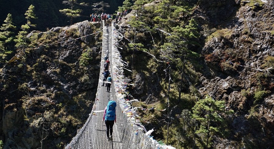
- Crossing enthralling suspension bridges, Crossing of Lamjura pass
- Witness Sherpa culture in Junbesi
- Visit largest monastery in Thubten Chholing
- View Yeti’s head in Khamjung village
- Panoramic view from national headquarter and from Everest view hotel
- Sherpa culture in Khumjung Village
- Visit Tengboche Monastery
- Beautiful mountain view from Kalapathar
- Spectacular view of glacier from Everest Base Camp
- View of icy glacier lake and Everest from the Gokyo Peak
Trip Itinerary
Expand AllAltitude: 1335 m Meals: Breakfast Accommodation: Hotel
Altitude 1790
Accommodation Tea House / Lodge
Meals Breakfast, Lunch, Dinner
Accommodation Tea House / Lodge
Altitude3530 m
A walk to the twin village of Khunde (3840 meters) and Khumjung (3780 meters) through the Syangboche Airport (3720 meters) is considered as one of the interesting days of the trek. With the benefit of gain in altitude, this day trip also offers a chance to visit a hospital and school started by Sir Edmund Hillary himself. Breathtaking views of Mount Everest (8848 meters), Lohtse (8516 meters) and Ama Dablam (6812 meters) are also an added incentive for the day hike. (6 hours)
The trek continues on a well maintained path in the morning with towering mountains on almost every direction. After passing a couple of teahouses at Kyangjuma, the path climbs to a different valley leaving the traditional Everest Trail and crosses Mong La and drops down to Phortse Tenga. With the disappearing views of Taboche peak (6501 meters) and Chola Tse (6440 meters), the trail slowly climbs and reaches Dole. (5-6 hours approximately)
Departures & Availability
| Depature Date | Price | Status |
|---|
Price include
In the Above Cost It Includes:
1. Airport Pick-up and Drop Off,
2. Licensed and trained trekking guides,
3. potters for carrying goods and supplies,
4. 4 Nights Accommodation in the 3 Star Hotel in Kathmandu with B & B. (Bed
& Breakfast)
5. All accommodation during the trek.
6. All meals and hot beverages during the trek.
7. Transportation to and from trail head.
8. All necessary documents and permits for trekking (where applicable)
9. National Park/Conservation Area entry Permit, Equipment such as tents And Mattresses, Cooking Equipment, Camp site charges, Insurance, and
equipment for the staffs.
10. Coordination of quick Rescue service (Costs covered by your Insurance Plan)
11. Trekking staffs wages etc.
12. 1 hr. trekker massage after your trek.
Price Excludes
Services and Cost Does not Included in Price:
1. International Airfares,
2. Travel/Trekking Insurance,
3. Excess baggage charges More than 16kg and hand bag more than 5 kg in
domestic flights.
4. Visa fees.
5. Airport Departure Taxes.
6. Drinks (Cold and Alcoholic) Rescue charge.
7. Tips for The staffs.
8. Expenses of Personnel nature and Permit and Liaison officer fee (where Applicable.
9. Meals during stay in the Kathmandu.
10. Domestic Ticket Etc.
Trip Information
Trip Information
The highlight of this trek is undoubtedly the stunning Gokyo Lakes, a series of turquoise alpine jewels nestled amidst the mountains. The ascent to Gokyo Ri also rewards adventurers with awe-inspiring views of Everest, Lhotse, Makalu, and Cho Oyu. However, the journey’s pinnacle challenge lies in crossing the Cho-La Pass, a demanding yet exhilarating high-altitude experience. The pass, adorned with glaciers and surrounded by snow-clad giants, connects Gokyo Valley to the Everest Base Camp route, offering a thrilling sense of accomplishment.
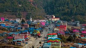
En route, trekkers encounter cultural treasures such as Namche Bazaar and the Tengboche Monastery, enriching the journey with insights into Sherpa traditions. The trail’s accommodations range from charming teahouses to tented camps, providing a blend of rustic comfort and genuine hospitality.
The Jiri to Gokyo Lake via Cho-La Pass trek is not merely a physical feat; it’s a spiritual and emotional voyage. It demands resilience, adaptability, and a profound connection to the natural world. The diverse landscapes, challenging terrain, and cultural encounters make this trek a transformative adventure, fostering personal growth and self-discovery. As trekkers stand atop Gokyo Ri, traverse the formidable Cho-La Pass, and immerse themselves in the serenity of the lakes, they forge memories and connections that will endure long after the journey’s end. This expedition captures the essence of the Himalayan spirit – untamed, majestic, and life-changing.
Trip Map

Gallery